
Stunning satellite images depicting the recent gigantic infernos that devastated one of the coldest areas on the planet have been released to mark Earth Observation Week (6-10 September).
Last month fires burning across Siberia – known for its cold and harsh winters – were bigger than all the fires burning across the globe combined.
An extreme heatwave coupled with an historic drought resulted in 10 times more fires in the Yakutia area than usual. Record levels of carbon dioxide were released as smoke from the raging forest fires travelled 3,000 km (1,800 miles) reaching the north pole for the first time in recorded history.
Experts at the National Centre for Earth Observation, based at Space Park Leicester, have released the images to demonstrate how data from earth observation instruments can be used to monitor changes in land use and urbanisation over time, which can feed in to improving planning and potential prevention management of large-scale forest fires worldwide.
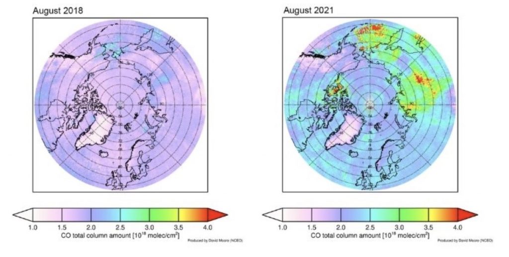
NCEO scientist Dr David Moore has used the University of Leicester Infrared Atmospheric Sounding Interferometer (IASI) Retrieval Scheme (ULIRS), which is funded and developed through NCEO, to plot the extent of pollution in August 2021 compared to an ‘average’ August in 2018.
He said: “Fires in Siberia happen every year, but this year in particular has stood out in terms of both the number and intensity of fires.
“Satellite datasets have shown huge amounts of smoke, aerosol and polluting trace gases from these fires being transported to the Arctic. Over 800 megatons of carbon dioxide has been produced from the fires, which has doubled the record set in 2020.
“With the changing climate it is not clear if the number of individual fires will increase or decrease worldwide, but what we are seeing in recent years, across many parts of the world, is that the intensity of the fires and consequent area burnt by fire is increasing.
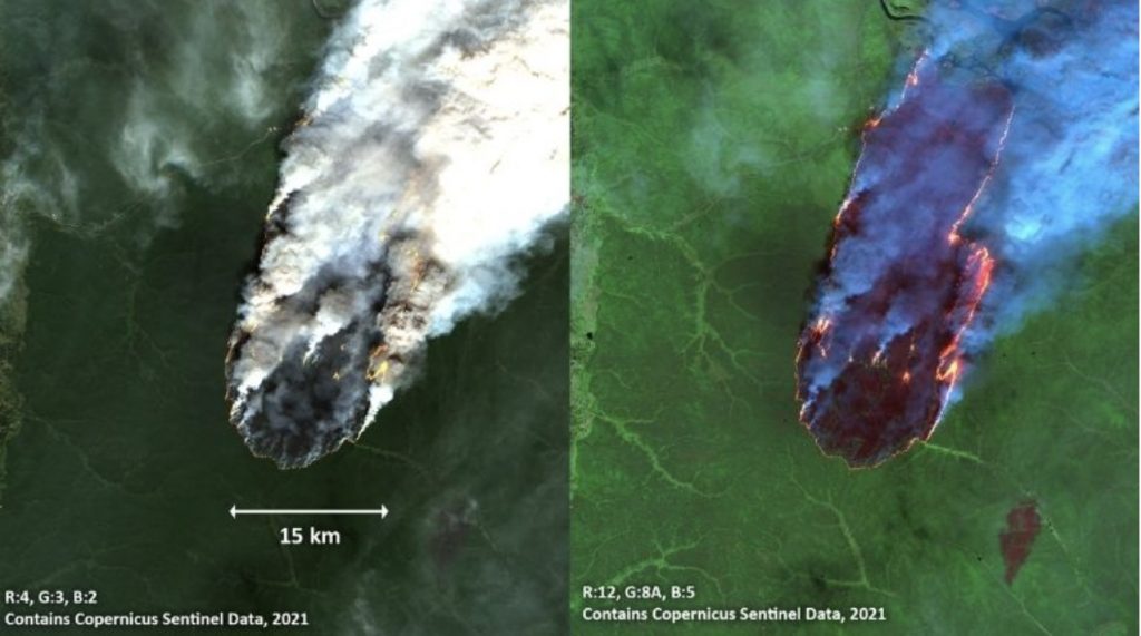
“The European Space Agency multi-spectral imager (MSI) on Sentinel-2 is a great tool for post-fire monitoring. The 10 m spatial-resolution of MSI data makes it possible to visualise areas of fire activity, contributing to disaster mapping and helping humanitarian relief efforts. Fires can be tracked over several different days and techniques exist to use the different wavelengths of the MSI data to classify the burn severity of the fires.”
According to Russia’s forestry agency, this year’s fires have ravaged more than 14m hectares, making it the second-worst fire season since the turn of the century.
Improvements in spaceborne imagers have led to major improvements in spatial resolution allowing experts to observe changes in the earth’s surface more quickly and accurately.
David added: “There has been a long history of spaceborne imagers, one example being the pioneering Landsat program which started in 1972 and has been providing repetitive multispectral data of the Earth’s surface since then.
“Over the last decade or so the most significant changes I’ve witnessed in spaceborne imager technology has been the improvement in spatial resolution from 60m at the start of the Landsat program to 15m in the most recent Landsat-8 imager.”
After the launch of a second Sentinel-2 in 2017, the repeat coverage reduced to five-days, which helps to improve the chances of a cloud-free overpass if studying processes at the Earth’s surface. A third Sentinel-2 satellite is due to launch in 2023 which will reduce the revisit time further.
The NCEO, whose headquarters are newly located at the Space Park Leicester, processes and analyses vast quantities of data generated by satellites, as well as by aircraft and ground-based assets to monitor and understand global and regional fire impacts.
Professor John Remedios of the Earth Observation Science Group at the University of Leicester and director of the National Centre for Earth Observation, added: “In our research and products, our experts across the UK are producing leading, trustable data sets and really driving towards the next generation of fire-relevant satellite missions. Convening the worldwide community and collaboration is an absolute imperative to meet the challenges of a changing world.”
To find out more information about the National Centre for Earth Observation (NCEO) visit nceo.ac.uk.
To find out more about Space Park Leicester visit space-park.co.uk.
 Subscribe to Physics & Astronomy's posts
Recent Comments