
Leicester scientist Neil Humpage helps to set up a new measurement site in northeast London, part of a ground-based remote sensing network to help understand the city’s air quality and carbon emissions.
On Friday 23rd April, Dr Neil Humpage from the Earth Observation Science group travelled down to northeast London to help set up a new suite of ground-based remote sensing instruments. Together with the Field Spectroscopy Facility (FSF), we established three different measurement sites across London during the course of the week as part of the NERC DARE-UK project. The instruments now running at these sites together form the FSF Spectral Atmospheric Suite, and allow continuous monitoring of the composition of the atmospheric column over the capital city.
We chose the three sites – the National Physical Laboratory in Teddington, the University College London Engineering Building on Torrington Place, and Highfields Tower in northeast London – to align with the prevailing wind direction over London, which blows from southwest to northeast. By looking at the differences between the atmospheric column concentrations recorded at each site, we can see how the composition of the air changes as it passes over the city, which in turn helps us to estimate the emission rates of different gases produced by the many different sources present in the urban environment.
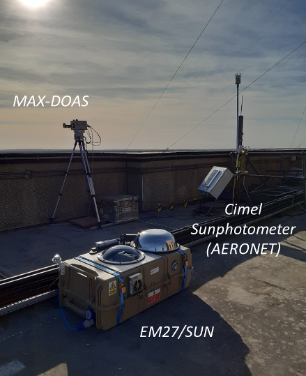
At each site we have set up three different remote sensing instruments, each able to measure the concentrations of different gases in the air over London. The Bruker EM27/SUN is a Fourier transform spectrometer, which measures shortwave infrared light at a fine wavelength resolution that we can use to infer the concentrations of greenhouse gases carbon dioxide and methane, along with carbon monoxide. The AirYX MAX-DOAS operates at shorter wavelengths (visible and near-infrared) which are sensitive to a range of pollutants including nitrogen dioxide, ozone, formaldehyde and sulphur dioxide, whilst we use the Cimel Sunphotometer (which will also form part of the AErosol RObotic NETwork, AERONET: https://aeronet.gsfc.nasa.gov/) to find out how much aerosol and fine particles are present in the air overhead.
Looking ahead, our intention is that this unique combination of instruments will give us an unprecedented picture of the air quality and carbon emissions over London, as well as providing valuable opportunities to evaluate the observations of various satellite instruments as they pass overhead.
 Subscribe to Physics & Astronomy's posts
Recent Comments